Life Science · Unit 5: Living together
Land and Water Ecosystems
Why do different living things live in a mountain stream, a forest and the salty Chesapeake Bay? You move a sampling boat down the James River in a simulation, then read real salinity numbers measured from the tidal James to the mouth of the Bay. Afterwards you can sort the living and nonliving parts of land, freshwater and marine ecosystems and use data to explain how salt decides what lives where.
Where this lesson sits
- Virginia SOL LS.7 a
- Practices LS.1 b, LS.1 c, LS.1 d, LS.1 f
Essential question: Why do different living things live in a mountain stream, a forest and the salty Bay?
-
Life Science (grade 7) LS.7 a You are here
This lesson
-
Biology
Preview it at high school level
In Biology you will follow one Virginia ecosystem as it changes over many years. This change is called ecological succession. You will see what happens when a farm field is left alone. Weeds and broomsedge grow first. Pines come next. After a century or more, an oak-hickory forest can stand there. Each stage changes the light and the soil, and those abiotic changes favor the next species. You will also compare land that starts with soil with bare rock that has none.
-
Biology II Biology II: Ecology, EC.7 b; Advanced Topics, BIOII.6 f
Preview where it goes next
Virginia’s Biology II: Ecology course (EC.7 b) studies primary and secondary succession, their stages, the climax community and how people change succession. Biology II: Advanced Topics (BIOII.6 f) asks how biodiversity helps an ecosystem handle disturbance. It adds resilience, how well an ecosystem returns after a disturbance, and tipping points, past which an ecosystem shifts to a different state and does not easily return.
-
College
Watch first Nonliving Things Help Decide Who Lives Where · 2:33
The James River starts as fresh water in Virginia’s mountains. It empties into the salty Chesapeake Bay at Hampton Roads, near Norfolk.
Along the way, river water mixes with salty water from the Bay. Wild oyster reefs grow in the brackish lower James. The river near Richmond is fresh water, where oysters can die. What changes along the river, and why does that matter? First, decide what you think now.
What do you think? Decide before you read.
-
Scientists disagree: Scientists who return to the same places find change. Aerial photos of the Chesapeake Bay show its underwater grass beds grew to about three times their size between 1984 and 2015. Population sizes, the kinds of species and the conditions in a place all shift over time.
What scientists think
Scientists disagree: Scientists who return to the same places find change. Aerial photos of the Chesapeake Bay show its underwater grass beds grew to about three times their size between 1984 and 2015. Population sizes, the kinds of species and the conditions in a place all shift over time.
-
Scientists disagree: Salt, sunlight and temperature decide which organisms can survive in a place at all. Eastern oysters, for example, can die when the water stays very low in salt (below about 5 parts per thousand) for a long time. Living things and their interactions matter too.
What scientists think
Scientists disagree: Salt, sunlight and temperature decide which organisms can survive in a place at all. Eastern oysters, for example, can die when the water stays very low in salt (below about 5 parts per thousand) for a long time. Living things and their interactions matter too.
-
Scientists disagree: Fresh water and ocean water differ in salt. They often differ in light, temperature and how the water moves, too. Different organisms live in fresh water, in the ocean and in the mixed water of an estuary between them.
What scientists think
Scientists disagree: Fresh water and ocean water differ in salt. They often differ in light, temperature and how the water moves, too. Different organisms live in fresh water, in the ocean and in the mixed water of an estuary between them.
Explore: take a boat down the James
In this simulation you see a side map of the James River, from the mountains to the mouth of the Bay. A slider moves a sampling boat along the river. A salinity bar shows how salty the water is at that spot, and the organisms that can live there appear or fade. A switch sets the season: a wet spring or summer.
Made up for this sketch: the river positions are not to scale; the spring setting moves the salty water one station down the river; wild celery fits under 1, widgeon grass from 1 to under 5 and eelgrass above 20 (the guide gives the oyster range). The summer numbers are the lesson’s means (Chesapeake Bay Program, June to August 2023, 1 meter below the surface). No tides, no depth layers.
The rule to keep: salinity, an abiotic factor, changes along the river, and each organism fits only where the salinity suits it. The organisms come from guides. Nobody counted them at these stations.
Try this.
- Predict where along the river oysters first appear. Then move the boat downstream from the mountains and check.
- In this sketch, does the salty water move up the river or down in a wet spring? Predict, then switch seasons and test.
- Park the boat mid-river. Predict which organisms live there in each season, then compare.
Explain: the living and nonliving parts of an ecosystem
- ecosystem
- biotic factor
- abiotic factor
- climate
- terrestrial ecosystem
- freshwater ecosystem
- marine ecosystem
- estuary
- salinity
An ecosystem is all the living things in a place, together with their nonliving surroundings.
A biotic factor is a living part of an ecosystem. Biotic factors include plants, animals, fungi and microorganisms, and the ways they interact. A deer eating acorns is biotic. You saw in Food Webs and Energy that dead parts and wastes of living things count as biotic too.
An abiotic factor is a nonliving part of an ecosystem. The main ones are:
- climate
- sunlight
- water
- soil
- air
- nutrients
Soil is mixed. Its sand, clay and minerals are abiotic. The worms, fungi and bacteria living in it are biotic.
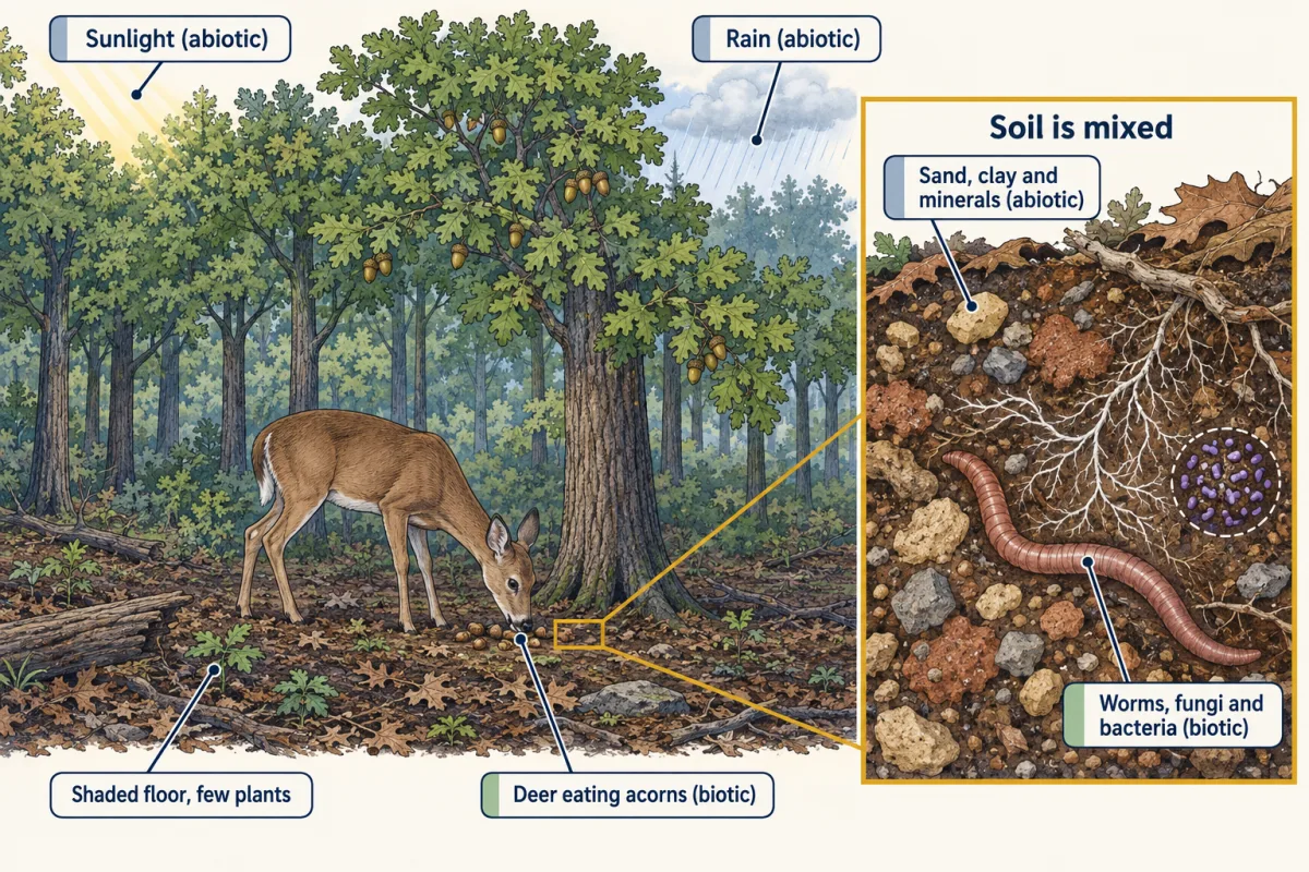
Abiotic factors decide which organisms can survive in a place. Few plants can grow on a forest floor that gets little sunlight. Water and floating mud block light, so few plants grow on the floor of deep or muddy water.
Explain: what shapes climate
Climate is the usual pattern of temperature and rainfall in a place over many years. Earth’s axis is tilted, about 23.4 degrees. As Earth travels around the sun each year, the tilt changes the angle of the sunlight and the length of the day. That is the main reason Virginia has hot summers and cold winters. It is not because Earth moves closer to the sun.
Temperature and precipitation (rain and snow) are the two main parts of climate. These things shape them:
- Latitude. Places farther from the equator usually get less direct sunlight and are colder.
- Elevation. The air usually gets cooler as you climb. A mountaintop in western Virginia is often cooler than the coast on the same day.
- Topography, the shape of the land. Mountains can make one side wet and the far side dry.
- Human actions. Burning fossil fuels adds carbon dioxide to the air, and it traps heat.
Climate, population sizes and the kinds of species all change over time, so ecosystems change too. You will see how living things fit their places in Adaptations for Survival (a later lesson).
Explain: land, fresh water and salt water
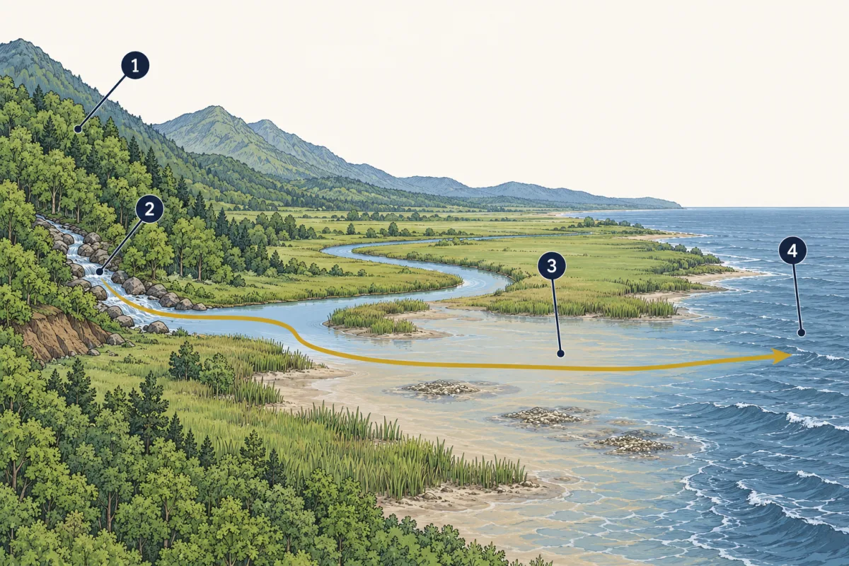
Scientists sort ecosystems into three broad groups. A forest, a mountain stream and the Bay each belong to one:
- A terrestrial ecosystem is on land, such as a forest or a field.
- A freshwater ecosystem has water with very little salt, such as a mountain stream, a lake or the upper James.
- A marine ecosystem has salty ocean water.
Salinity is the amount of salt dissolved in water. An estuary is a place where fresh river water mixes with salty ocean water. The Chesapeake Bay is an estuary. Its salinity is in between, and it shifts with rain and season.
| Abiotic factor | Terrestrial (Virginia forest) | Freshwater (mountain stream) | Estuary (Chesapeake Bay) | Marine (open ocean) |
|---|---|---|---|---|
| Salt | Little in most soils | Very little, under about 0.5 parts per thousand | In between; changes with rain | High, about 35 parts per thousand |
| Sunlight | Blocked by tree leaves | Reaches the bottom of shallow, clear water | Fades fast in muddy water | Fades with depth |
| Temperature | Changes a lot by season | Cool, often shaded | Changes by season | Changes less |
| Water movement | Rain and runoff | Flows one way, downhill | Tides and river flow mix | Waves and currents |
| Soil | Main source of nutrients | Rocks and gravel on the bottom | Mud on the bottom | Sand and mud far below |
- terrestrial ecosystem
- freshwater ecosystem
- estuary
- marine ecosystem
- terrestrial ecosystem
- blank
- blank
- marine ecosystem
Word bank: estuary, freshwater ecosystem
- blank
- blank
- blank
- blank
Check your labels
- terrestrial ecosystem
- freshwater ecosystem
- estuary
- marine ecosystem
Elaborate: salt along the James
Crews working with the Chesapeake Bay Program measure the water at the same stations about once or twice a month. The table shows their summer means, from the upper tidal James to the Bay mouth. Salinity is in practical salinity units (PSU). In Bay data, 1 PSU is about the same as 1 gram of salt in 1,000 grams of water.
| Station | Place | Samples | Mean salinity (PSU) | Organism that fits this salinity |
|---|---|---|---|---|
| TF5.5 | Upper tidal James | 3 | 0.09 | Wild celery |
| RET5.2 | Swann’s Point | 3 | 1.32 | Widgeon grass |
| LE5.1 | Near Red Buoy 36 | 3 | 4.53 | Widgeon grass |
| LE5.2 | Buoy C12-13 | 3 | 11.54 | Eastern oyster |
| LE5.3 | James River Bridge | 3 | 15.39 | Eastern oyster |
| LE5.4 | Hampton Roads | 3 | 20.67 | Eelgrass |
| CB8.1 | Between the James mouth and Thimble Shoals | 6 | 23.06 | Eelgrass |
| CB7.4 | Chesapeake Bay Bridge-Tunnel | 6 | 25.78 | Eelgrass |
Source: Chesapeake Bay Program DataHub, water samples taken 1 meter below the surface, June to August 2023 (Virginia DEQ and Old Dominion University). We calculated the means. The organisms come from Chesapeake Bay Program species guides. They were not counted at these stations.
- Describe the trend in salinity from TF5.5 to CB7.4.
- How much saltier was LE5.4 than TF5.5?
- A Chesapeake Bay Program guide says salinity from 10 to 28 is good for eastern oysters, and oysters can die if it stays below 5 for a long time. Which stations fall in the good range, and which fall below 5?
- As the water moves toward the Bay, salinity blank.
- Oysters fit station blank because its salinity, blank, is between 10 and 28.
- One reason this data cannot prove oysters live there is blank.
Claim, evidence, reasoning
Make a claim that answers the essential question: why do different living things live in different parts of the James and the Bay? Use the salinity table.
Start with: Different organisms live along the James because blank changes from place to place.
Start with: Mean summer salinity rose from blank PSU at TF5.5 to blank PSU at CB7.4, and oysters fit best at the stations from blank to blank.
Start with: Salinity is an abiotic factor. Each organism can live only where salinity is blank, so blank.
Compare with a model answer
Different organisms live along the James because salinity, an abiotic factor, changes along the river. In summer 2023, mean salinity rose from 0.09 PSU at TF5.5 to 25.78 PSU at CB7.4. Oysters fit stations LE5.2 to CB7.4, where salinity was between 10 and 28, and not the low-salt upper stations (TF5.5 to LE5.1). One limit: these are a few summer samples from one year at 1 meter deep. Nobody counted oysters, and rain or tides can change salinity.
Saved in this browser only.
Design problem
Brine shrimp are tiny animals sold as dried eggs for fish food. Plan a fair test of how salinity affects how many brine shrimp eggs hatch.
One way to do it
- Question: How does the amount of salt in water affect how many brine shrimp eggs hatch?
- Independent variable: salt per liter of water: 0, 10, 20, 30 and 40 grams.
- Dependent variable: number of hatched shrimp counted in a 1-milliliter sample after 48 hours.
- Constants: same bottled water, same kind of salt, the same small scoop of eggs, same temperature, same light and same cup size.
- Control: the cup with no salt shows what happens in fresh water.
- Trials: three cups at each salt level. Find the mean for each level.
- Safety: wear goggles, wash your hands, use eggs from a store, and do not pour shrimp into a stream or pond.
If hatching changes a lot from one salt level to another, salinity may limit where brine shrimp live. A cup is a model, not a real bay.
Evaluate: check your thinking
As the James flows toward the Bay, it mixes with salty water, so salinity rises. Oysters can die in water that stays very low in salt for a long time, so their reefs grow in the brackish lower James, and the fresh water near Richmond is poor oyster habitat. Salt, sunlight and climate, together with the living things, decide who lives in each ecosystem.
Science practices you used: making predictions with a model and testing them, reading a data table and finding a difference, making a claim from evidence, and planning a fair test with a control.
How we measure it
Water-quality monitoring stations
Crews return to the same marked spots in the James River and the Bay many times a year and measure the water about 1 meter below the surface. A probe can estimate salinity from how well the water carries electricity, so the same spot can be compared from month to month and year to year.
Aerial surveys of underwater grasses
Scientists photograph the shallow Bay from airplanes and map the beds of underwater grasses. Comparing the maps from many years shows whether the grass beds are shrinking or spreading.
Finish line
Test yourself
8 questions
Practice and MCAT-style, with explained answers.
Next · Lesson 21
Daily and Seasonal Rhythms
How does a cherry tree with no calendar know when to bloom, and why might that day change?
Continue →